Haven't written on here in a long time and have a lot to catch up on including hikes up Mt Massive and Mt Sherman, a great 4th of July weekend in Telluride which included knocking of Mt Sneffels, and a slightly disappointing Pike's Peak Ascent in August. But all that led up to the Jungfrau Marathon and I'll start there and over the next few weeks work backwards.
Early this year, two very good friends of mine, Fio and Riley, convinced me to go to Switzerland to race the
Jungfrau Marathon. A 26.2 mile race starting in Interlaken, that then winds its way up the valley to Lauterbrunnen before climbing up to Wengen and than upwards to the finish at Kleine Scheidegg, at the base of the Eiger. In total, about 6000 vertical feet of climbing, mostly in the last 10 miles of the marathon. It's a mix of road and trails and runs thru towns and small villages before climbing above treeline, so that in the last few miles there are amazing views of the north face of the Eiger and glaciers on the Jungfrau.
View Larger Map
The race had been on my radar for a number of years. It sounded like an amazing challenge. But more importantly, it would allow me to travel back to the Lauterbrunnen valley, 19 years after I had visited it my first time. After graduating high school, I spent 3 weeks in the summer traveling Europe. 3 of those days were spent staying in Wengen, above Lauterbrunnen. It was an amazing place. At the time I was horribly out of shape, having broken my ankle right before my senior track season. I was unable to do any running on the trip. I always wanted to get back and run the trails around the valley. Now I could also race them.
On September 11, I found myself heading to DIA airport in the middle of a deluge. Rains of biblical proportions were starting to hit Boulder. On the bus ride out to the airport, the windshield wiper on the driver's side of the bus fell off. The driver tried to fix it, but ultimately couldn't see and had to stop at the park and ride at Sheridan and 36, just a few miles outside of Boulder. We all had to wait for the next bus. During that time I had the thought that it was raining a bunch. And had been doing so for most of the afternoon. Little did I know this was just the beginning. As I was boarding my plane that evening to fly to Zurich, things would just be starting to get bad in Boulder. On Thursday, as I was landing in Zurich, Lyons would be completely flooded. This unfortunately is where Swiggy and Laura, friends of mine, live. And where Brisco was staying while I was out of town. As I was heading to Lauterbrunnen on Friday, Brisco was being evacuated by the National Guard.
http://www.youtube.com/watch?v=faSTFKMHmXs
Check out who is unloaded from the trucks at 0:38 into this clip.
It would be weird seeing pictures of Boulder on the front pages of Swiss papers the next few days.
On my end, the trip was relatively smooth. The only oddity was when I arrived in Zurich. The concourses were oddly dark. As I approached customs I realized there was a power outage in the airport. Didn't expect to have a glitch like that occur while in Switzerland. The custom agents also didn't seem to expect this to occur as they were all a bit befuddled. But power was restored quickly and I cruised thru customs, got my bag, got on a train, and shortly was in Alt Stadt Zurich.
Found Riley and Fio, had a beer, went out for dinner, then a few more drinks.
 |
| Strange challenge at a bar in old town Zurich. |
 |
| Climb thru the rafters to win the challenge. |
 |
| Your prize : Drinking a glass of wine (of sorts) upside down. |
After Thursday evening's shenanigans, finally got to Fio's place. Night one, didn't sleep well at all. Slept for about 3 hours then was up the rest of the night. This would be a trend.
On Friday morning, got out and did light jog to try to get body onto right time. Then picked up our ride for the weekend.
 |
| Good thing it was a convertible, otherwise 3 guys and luggage would not fit in a Mini. |
This might not have been the most practical choice of transportation, but it was fun. Time to head to Lauterbrunnen.
Stopped in Breinz for lunch along the lakefront before heading on to Lauterbrunnen.
 |
| Lunch, lakeside. |
Arrived at our chalet where we would be staying for the next few days in Lauterbrunnen. It had fantastic views of Staubbachfall and the valley.
 |
| Our abode for the next few days in Lauterbrunnen. Had 3rd floor apartment. |
 |
| Views of the valley from the balcony. |
 |
| Staubbachfall |
The crew was ready for next day's challenge.
 |
| The gang. |
Night two, didn't sleep well again. Slept about 3 hours before being wide awake again. Tried not to toss and turn to much. Did finally fall back asleep and get about another hour of sleep before alarm went off Saturday morning. Race day!
The weather forecast was iffy. The forecast had called for rain on Saturday. It was a bit overcast when I awoke but didn't seem to bad. Just kept fingers crossed. After breakfast, we were out the door. A 10 minute walk got us to the train station. Then it was a 15-20 minute ride to Interlaken.
 |
| Riley and Fio on train to start. |
 |
| I am confident. And completely naive. |
Arriving in Interlaken the weather looked promising. It was cool, probably 50 degrees, a little cloudy, but looked like it was going to be a good day.
 |
| Good day to race! |
I felt good and the atmosphere was fantastic. Having run a lot of trail races the last few years, I had forgotten the energy levels that surround the start of a big road race. The Jungfrau Marathon has about 4500 runners. With that many runners, their supporters and the general population of Interlaken all out on the streets, it was quite a scene.
 |
| START |
So the start was like a major road race. Thousands of people cheering. There was fireworks or a cannon going off. The race does a 2 mile loop of Interlaken before coming back thru the start area. It was hard to not go to fast with all the people cheering. I did feel like I got into a relaxed pace quickly and just soaked in everything. Somewhere in the 2nd mile I passed Riley and slowly pulled away. My first miles were a little quick. (or so I thought at the time). I was planning to run 6:52 pace the first half marathon. My primary goal for the race was to run sub 4 hours. My secondary goal was to try to get near Melody Fairchild's time of 3:45 which she had run hear in 2012. At that time she was my housemate, so I had fair idea of what shape she was in when she ran that and I felt I was at a similar level. That meant running the first half in roughly 1:30 and then the second half in 2:15.
I was sure those first two miles were closer to 6:40. But I was able to get back around 6:50 after those early miles. Looking at my splits after the race, my chip split at 3km was 13:28. I'm not sure I believe that.
After leaving Interlaken, we entered the next town of Bonigen. What would be seen over and over in each town was first really noticed in Bonigen. Guys were ringing huge cow bells. These were the size of basketballs. They were strapped to a belt around their waist and they rang them as if they were twirling a hula hoop. Then there was an oompah band. And all the residents out on the streets encouraging everyone to "hopp". I heard that all day. "hopp, hopp, hopp" Literal translation would be chop-chop. It's really just yelling go, go.
After leaving Bonigen, entered the Swiss countryside and began to wind up the valley to Lauterbrunnen. During this stretch, I thought I heard more cannon fire. Off in the distance I saw what appeared to be targets that you would expect at a shooting range. The noise continued. I'm not sure how to describe it, but it didn't sound like normal gun fire, but that's what it was followed by a metal twang as a bullet hit the targets. I soon approached the gun club/shooting range building and realized the targets had to be a quarter mile away. I don't what these guys were shooting. A few of them were outside the building cheering on the runners. "Hopp, hopp" It was crazy. It sounded like what I imagine a small missile would sound like being fired.
Leaving the gun club behind, we entered Wilderswil. More cowbells, more oompah bands, more people yelling "Hopp, hopp"
I was feeling very good and comfortable. Holding steady at my 6:50ish pace. This was the 10k checkpoint. My split was 42:36. That is exactly 6:52 pace. All was good. (I was 234 overall male at 10K)
The first slight uphill was shortly after 10k. Around 13k was the first gravel road. At this point, it was all asphalt. The next few miles were thru wooded terrain along the river and train tracks. My 10 to 15k split was 22:17. That would be 7:11 pace. (I picked up a few spots to 201st male overall) Somehow, I didn't register this slight slow down here. But still felt okay and comfortable. The small town of Zweilutschinen at 15K would be the last town for a awhile.
The next 4 miles until Lauterbrunnen were pretty much all on trail or gravel road. It was around this point I began to feel a bit off. My legs were feeling just a bit heavy. I tried to relax the pace a little bit as I knew I had a long way to go. Entering Lauterbrunnen was quite amazing. There were hundreds of people cheering us. I was a bit surprised at this point to also see Riley. He had caught up with me. We went thru the halfway point in 1:35:16. That would be 7:16 pace for 13.1 miles. (I was now in 234th male overall). As Riley caught me, I told him I wasn't feeling it. The last mile before town I began to struggle just a bit with my form. My legs didn't seem very peppy. I knew I wasn't going to break 4 hours. I don't know if it was the travel and not getting sleep, but I wasn't 100%. I would still run hard, but I didn't have any illusions of running a great race. I would now try to really enjoy everything and not worry too much about time.
The next 4k went out of Lauterbrunnen, up the valley a bit, then back to Lauterbrunnen. The sheer vertical of the valley walls is ridiculous. The walls rise 2000 vertical feet straight up from the valley floor. And the valley is only 1/2 mile across. It is a breathtaking spot. Riley pulled away easily. I couldn't respond. My form didn't feel relaxed anymore.
As I re-entered Lauterbrunnen, my split from 21.1km to 25.6 was 20:51. That's 7:28 pace that last 2.75 miles. My legs were feeling way to heavy than I had planned before the climb started. I think I underestimated how much all the running on the asphalt would take out of my legs. And even though I had done a number of really long runs, I hadn't done many 15 miles runs at 7 to 7:15 pace. Most of my long runs were in the mountains at much slower pace. So 13 miles mostly on road, mostly flat, at 7:15 pace took more out of my legs than I thought would happen. And so there was a part of me that actually was looking forward to climbing. Climbing is what I had been doing all summer. Maybe the climb would rejuvenate me.
From the start to the 16 mile point, we had gained 480 vertical feet. At the 16 mile point the real climbing began. The initial climb would go from Lauterbrunnen to Wengen.
The climb to Wengen is hard. Very hard. In a mile, the climb gains nearly 1100 vertical feet. The switchbacks are very short. It is basically straight up. The climb destroyed me. Halfway thru it, I was no longer thinking this was better than the fast running on flats. By the time I entered Wengen I knew the rest of the race was about survival. My split from 25.6km to 30.2km was 41:29. I had dropped to 332nd male overall. I had the 744 fastest split from 25.6 to 30.2. Considering all my previous splits were around 200th fastest, it shows how much I slowed. People were streaming past me now.
 |
| Running thru Wengen. Hurting. And I got 8 miles to go. |
But even though I was really starting to struggle, Wengen was amazing. The crowds were 3 or 4 deep on both sides of the road. And they were all out in the road, leaving just a small path down the middle. It was just like the European experience in a bike race. "Hopp, hopp."
 |
| Crowds in Wengen were fantastic. |
That really helped me to recover from that climb and pushed me along a few miles. After leaving Wengen, we pretty much wouldn't pass thru anymore villages. It would be the last of the asphalt. Now it was trails thru the upper forest and then eventually above treeline. The climbing became relatively more gentle. From 17 to 23 miles, we "only" gained 800 vertical feet. But I was trudging along. There were actually still a fair amount of folks in pockets along the course. "Hopp, hopp," they went. And another oompah band. I was now drinking coke and bullion at the aid stations. I was still running, but it was a shuffle.
My split from 30.2km to 37.9km was 1:11:49. The 1181st fastest split. I was now 510th male overall. That's 15 min per mile pace over 5 miles with a relatively small gradient (130 vert ft per mile). Not exactly crushing it.
At 23 miles, the course is now all above treeline. Up until this point the trail was very wide and really well maintained. Smooth gravel. Now the trail headed straight up and thru a cow pasture. It became single track and some places non-existent. Looking up, the north face of the Eiger towered over everything. And looking very small in comparison, a line of people snaked upwards.
 |
| Alpine horns. Glaciers. North face of the Eiger. No race can compare. |
The alpine horns were really cool, but a bit too melodic for me at this point. I could have used them early in the race to slow me down. Here, it sounded like I was attending my funeral. I needed an oompah band. Something upbeat. Still, in what other race do you get to experience this?
This was now all power hiking, if you can call it that. From 23 to 24 miles, the course climbs 1500 vertical feet.
 |
| The last few miles are a slow crawl. |
I was done. I was trying to not slow down the line and get out of the way when I could, but still felt like I was getting in people's way. I did put on a smile for the cameras.
 |
| Smile for the camera. This is fun. |
 |
| This seriously is the scenery. I have not been photoshopped into this picture. |
From 24 to 25 miles, the course climbs an additional 800 vertical feet. It was really mentally crushing to keep looking up and seeing this line of people going on and on with no end in sight. Still there were a scattering of folks along the trail cheering us on. "Hopp, hopp."
 |
| The last part of the climb. |
From 25 to 25.5 miles another 300 vertical feet are gained. At the top of this climb a single bagpiper played. Now I definitely felt like I was attending my funeral. The last hour had felt like a death march.
But now it was downhill to the finish. I initially couldn't get my legs to run again. They agreed to shuffle a bit as we passed the small lake near the finish.
But as I got to the downhill after the lake, they began to turn over. Now I just was trying to stay upright and have a strong finish.
 |
| Simply the Best |
It seemed like ages ago when we were all together back at the chalet in Lauterbrunnen having breakfast wondering what the day would hold for us. Fio, of course, was playing Springsteen as motivational music. Then he put on Tina Turner's "Simply the Best." I have no idea the last time I had heard that song. And it definitely is not the first thing I think of when putting together a motivational play list. But since she currently lives in Switzerland and recently had gotten married here (I did see the shop in Zurich that wouldn't show Oprah a handbag when she was in town for Tina's wedding), I suppose it was appropriate. Imagine my surprise as I am coming into the finish and "Simply the Best" is blasting over the loudspeakers. The song I hadn't heard in years and now I heard it twice in a day. It put a smile on my face as I crossed the finish line. Oddly it seemed perfectly appropriate.
My time : 4:37:46. It took me 48:18 to cover the last 4.3km. 1187 people would run faster than me in that last split. Finished 592nd male overall. It wasn't what I had planned but it didn't matter too much. It was one of the hardest races I have ever run and I was happy to finish the challenge. And it was an amazing experience overall.
 |
| Post Race Smiles. That was hard! |
 |
| There can't be many finish lines with this view. |
After finishing and finding everyone, it was time for a beer.
 |
| Beer and Coke. Recommended post race re-hydration. |
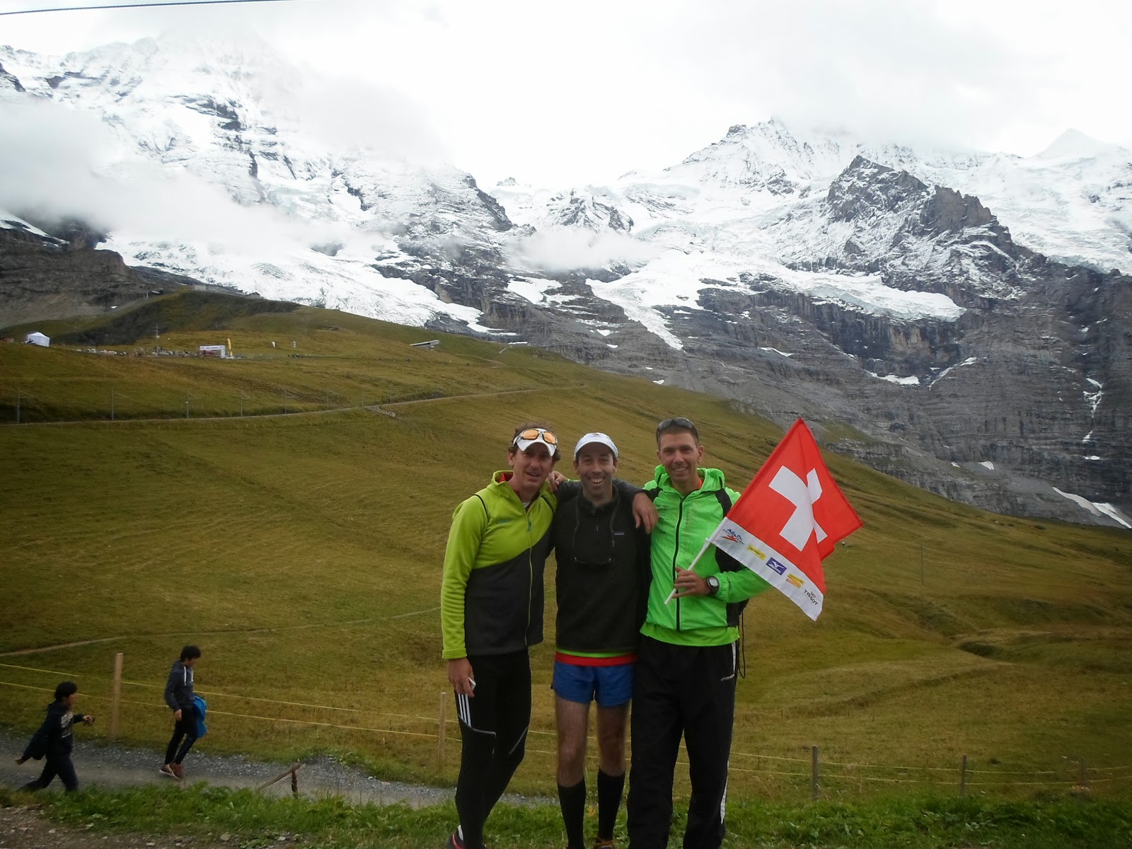 |
| The gang at the top. |
Will I be back? Not anytime soon. But I could see myself returning. There is a bit of unfinished business to take care of. I know I hadn't fully adjusted from the travel. The night after the race, when i should have been exhausted I still didn't sleep well. I really wouldn't get in a good night of sleep until Monday night. When I raced Berlin Marathon in 2005, I got in 3 days before, not 2, and had adjusted my schedule back in the States, running at 4am in the morning to start to make up for the 8 hour time difference. This time, I didn't have the ability to get in 3 days before or do 4am runs. Riley and Fio had great races and I finished, so it was a good day. And the whole trip was fantastic. More on that to follow.
For full set of pictures from pre-race day and race-day click on pic below :


